
Many of my recent days have been spent researching new
hikes, as well as doing some small hikes to be added to this "2Small 2B Big" blog.
I've also done a sprinkling of conventional hikes to
conventional places. However, it seems
pointless to write a blog report for these types of venues unless there is
something to be said that hasn't already been said by others, and/or some
photos that show something that is significantly different from what has been
posted countless times on various websites, forums, and blogs.
On one of my small hikes I recently 'discovered' a trail
that has been 'hiding' from me in plain sight!
Just a few steps away from Memorial Tree at Bretzfelder Park in Bethlehem
is a segment of the Heritage Trail. Since this trail is not solely contained
within the boundaries of the Bretzfelder property, I assume that is why it is
not included on the trail map brochure at the trailhead parking lot. And, I guess that's why I've been unaware of
this trail on my previous visits to Bretzfelder Park!
For readers who are unfamiliar with the Heritage Trail,
click HERE for some background
information. Basically this trail system
was conceived in the late 1980s, but the idea never really took off. The corridor was to have run north from Massachusetts
along the Merrimack River to Franklin where it would join the Pemigewasset
River and go through Franconia Notch to Lancaster, then follow the Connecticut
River to Canada.
The New Hampshire
Conservation Corps constructed 10 miles of trail in Franconia Notch State Park. In the early 1990s, Bethlehem, Manchester,
and Nashua dedicated Heritage Trail segments. There are other communities who have also constructed and actively maintain segments of this trail. One particularly nice segment in the North Country is in the Lancaster, NH area (Click HERE).
Shown below is a snippet of the Bethlehem portion of the
Heritage Trail. Nearly the entire Bethlehem
portion of the Heritage Trail runs on public roadways from the Pierce Bridge area on Rt. 302 to the
Bethlehem/Whitefield boundary on Kimball Hill Road. Shown below is just a small snippet of the
Bethlehem portion of the Heritage Trail.
 |
| Map showing small snippet of Bethlehem portion of the Heritage Trail |
The only portion of the Heritage Trail in Bethlehem that goes
through a woodland pathway is what I'll call the "Bretzfelder segment".
This wooded corridor runs for about a
mile between Memorial Tree at Bretzfelder and the stone pillars on Prospect
Road which mark the entrance to what was once the Stonecrest Estate (see next
photo).
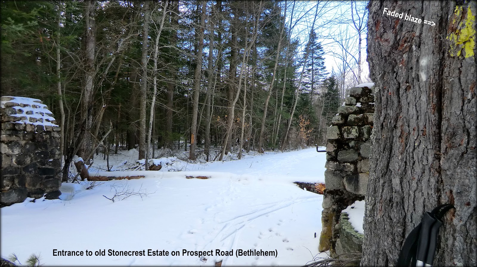 |
| Entrance to what was once the Stonecrest Estate |
The "Bretzfelder segment" is easy to follow from
Bretzfelder's Memorial Tree to the point where it junctions with a snowmobile
trail. It is well-blazed in yellow, and
there is a Heritage Trail sign near Memorial Tree, and there is another one at
the junction with the snowmobile trail.
 |
| Heritage Trail signs (near Memorial Tree, and at junction with snowmobile trail) |
After reaching the junction with the snowmobile trail, it
can be challenging to follow the trail forward to the entrance of the
Stonecrest Estate on Prospect Road.
Basically, you hang a left at the snowmobile trail and follow it for
perhaps a tenth of a mile or so. Then,
at a sharp right turn, you leave the snowmobile trail and follow a wooded
corridor down to Prospect Road. Be aware
of one sharp right turn along the way.
The wooded pathway, which was described above, is just a
bit over a mile in length. It's a
terrific corridor for a short XC-ski, or for a snowshoe hike. Since I just discovered this little gem, I
have no idea about how it is to hike this corridor under summertime conditions.
This small hike along the "Bretzfelder segment" offers no sweeping vistas, nor does it
have any other distinguishing landscape features such as a pond, or
waterfall. It is merely a delightful
little walk in the woods, which is sometimes all that one needs! But of
course, you can extend your trek to include another portion of the Heritage
Trail by strolling down Bethlehem's Main Street where you can enjoy curbside views
of the Presidential Range while visiting shops along this route.
(In recent days, I
researched another small hike in the Gorham area. This one has some views. Click HERE
to view that report.)
~ THE END ~
That's very interesting, John! I've seen the Heritage Trail signs in several locations (Kimball Hill Road heading toward Lancaster, crossing the Skookumchuck trail, Dixville Notch, even on a post when getting off I-93 in downtown Concord)! I often wondered if they all linked together somehow and if there was a map of the whole thing - sad to hear that they do not.
ReplyDeleteNice report! I would be interested in where you obtained the small Bethlehem map. Of course, after posting this I may find it waiting online! :)
Hi Chris,
DeleteGlad you found the report to be of interest, and thank you for your kind comments!
The map was obtained via the courtesy of Cheryl Jensen who is the Chairperson of the Bethlehem Conservation Commission. Via personal e-mail, I'll be sending you the map and other information received from Cheryl.
John
You know, I've seen that sign in Concord that NeoAkela referred to many times (I go there just about every day!) and could never figure it out. I knew it wasn't the AT, as that is much further north. Now I know, too bad there isn't a complete trail or map.
ReplyDeleteFinally got over to the new blog, late to the party as usual!
Hi Summerset,
DeleteThanks for dropping by the new Blog.
It’s too bad that the Heritage Trail really never took off. Maps of the existing snippets of this trail system are often hard to come by. And, many of the segments that were constructed (and still survive) often rely upon public roadways for some portions of the trail. As mentioned in my Blog, this is certainly true in Bethlehem. Although I must say that the public roadways chosen for the Bethlehem route are very scenic, and lightly used. One particularly scenic roadway runs along the Ammonoosuc River, and it is so lightly used that I can ride my bike there and routinely see more bicyclists than motorists!
Most likely you’ve already done some research about the Heritage Trail segment in the Concord area. But if not, the link below has a map which might be of interest.
http://www.concordnh.gov/Facilities.aspx?Page=detail&RID=71
John