Recently, I've spent many enjoyable days exploring trails
that begin at the Fox Hill Park trailhead in Franconia, NH. These explorations have been done on X-C
skis when conditions have permitted, and have been done on foot following a
recent warm up and resulting snowmelt.
To get the most out of explorations in this area, it's
highly recommended that you purchase a copy of a $2.95 map entitled
"Franconia Area Trails". This
map is available at various retailers in the village of Franconia. It can also be ordered online from Bondcliff Books, and if you are in Lincoln, most likely Steve Smith will have a copy at
his Mountain Wanderer Bookstore. Be
aware that this map is different from another map with a similar name, i.e. "Franconia Notch Map & Guide".
The Franconia
Area Trails Map is too large to show in this blog, and besides it contains
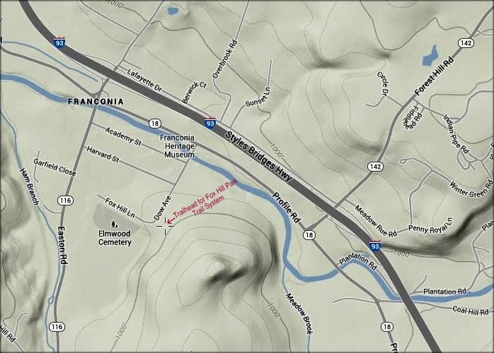
copyrighted material. However, presented
below is a snippet from a publicly available map. It shows the location of the
trailhead parking lot at Fox Hill Park where there is room enough for about 3 to 4 cars.
If you don't
have the map mentioned above, you can simply head off on the trails and do some
independent exploration. But map or no
map, I would suggest you begin your trek on the Gale River Trail which leads
you along the picturesque Gale River.
Having the map will enable you to construct a variety of loop
options beyond Fox Hill Park that can vary in distance from less than a mile, or upwards to about 4
miles.
Shown below are
some photos taken during my recent treks in early
January.
 |
| Franconia Range as viewed from Lovetts Loop |
 |
| Zoomed view of Mt. Lafayette from Lovetts Loop |
 |
| Beaver dam along the Meadow Brook Trail |
 |
| Ice jam along Gale River following "January thaw" conditions |
If you are
interested in two other short winter hikes that I've recently done, they can be
accessed by clicking/tapping on the report titles shown below.
~ THE END ~


No comments:
Post a Comment